


Press Release
Development and Introduction of an "Autonomous Flight System for Transmission Line Inspection Drones" that Enables Autonomous Drones to Follow and Photograph Transmission Lines
May 11, 2021
Tokyo Electric Power Company Holdings, Inc.
Blue Innovation Co., Ltd.
TEPCO Systems Corporation
TEPCO Power Grid, Inc.
Tokyo Electric Power Company Holdings, Inc. (Headquarters: Chiyoda-ku, Tokyo; President: Tomoaki Kobayakawa; hereinafter referred to as, "TEPCO HD"), Blue Innovation Co., Ltd. (Headquarters: Bunkyo-ku, Tokyo; CEO: Takayuki Kumada; hereinafter referred to as, "Blue Innovation"), and TEPCO Systems Corporation (Headquarters: Koto-ku, Tokyo; President: Yuji Gonda; hereinafter referred to as, "TEPSYS") have developed an "Autonomous Flight System for Transmission Line Inspection Drones" (hereinafter referred to as, "System") that will be put into use in June by TEPCO Power Grid, Inc. (Headquarters: Chiyoda-ku, Tokyo; President: Yoshinori Kaneko; hereinafter referred to as, "TEPCO PG") to inspect its transmission lines.
(Commencement of joint development of the system was announced on March 24, 2017 <Japanese only>)
The System was developed jointly by TEPCO HD, TEPSYS and Blue Innovation based on the Blue Earth Platform※ developed by Blue Innovation. Conventionally, TEPCO PG has used primarily telescopes and helicopters to visually inspect transmission lines. However, with the introduction of this System autonomous drones equipped with object detection sensors (which can be installed on typical drones) and cameras can be used to detect transmission lines and photograph abnormalities (example: corrosion, degradation, etc.) from optimal angles thereby greatly improving efficiency and reducing costs associated with inspection work (patent pending).
![[A drone inspecting transmission lines]](/en/hd/newsroom/press/archives/2021/images/210511e01g01.png)
[A drone inspecting transmission lines]
Challenges with overhead transmission line inspections
TEPCO P&G owns 28,391 km (total in all of Japan: 151,862 km) of overhead transmission lines which it visually inspects using primarily telescopes and helicopters. These visual inspections require a vast amount of time and highly skilled workers, so being able to implement the increasing number of inspections required as facilities age is a challenge that must be addressed considering the future labor force shortage that will occur as a result of Japan's low birth rate and aging society.
Using autonomous drones for inspections has been considered in the past in order to increase inspection efficiency and reduce costs, but practical application has been plagued by the following technical challenges.
- As drones get close to transmission lines, the magnetic field created by the electric wires hinders the drone's ability to navigate thereby resulting in unstable flight control (technology that enables the drones to fly autonomously while maintaining a fixed distance from transmission lines is required).
- Since electric wires change shape depending on the current value, temperature, and wind, etc. it is difficult to predict the shape of the electric wires in advance and preset a flight route that follows the wires (technology that allows the flight route to be automatically set/adjusted in real time is required).
In order to solve these challenges, we have jointly developed object detection sensors for detecting the position of transmission lines, control technology for maintaining a fixed distance between the drone and the transmission lines, and vibration control technology for enabling crisp and clear photographs of transmission wires. Additionally, an application dedicated to transmission line photography was developed to make it easier for workers in the field to use.
Drones can fly along transmission lines without being affected by changes to the flight environment
The object detection sensors employed by the System differ from systems that detect transmission lines through image analysis and can accurately detect transmission lines without being affected by direct sunlight, shadows, or similar structures.
During demonstration experiments between transmission towers with 365 m distance, the drones flew parallel to the transmission lines and were able to take pictures from a consistent angle.
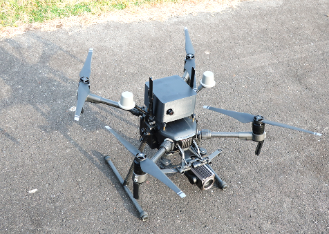
<Drone equipped with object detection sensors>
The module attached to the top enables the detection of transmission lines as well and drone/vibration control
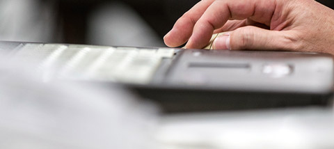
Simple one-click operation
One click of the dedicated application enables the drone to take off/land and take photographs of transmission lines autonomously.
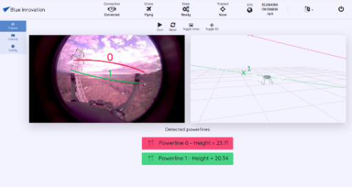
System operating screen
Photographed images can be viewed in the field
Since the drone flies autonomously, workers do not have to operate it manually and can concentrate on checking the photos of transmission lines sent back in real time from the drone. If something requires close inspection, the drone can be stopped right there and then, and the cameras can zoom in to take more detailed photographs of the conditions of transmission lines.
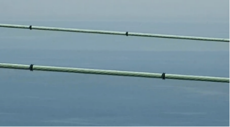
Photographs from a drone
※What is the Blue Earth Platform* (BEP)
The Blue Earth Platform is a proprietary platform developed by Blue Innovation that enables multiple drones or robots to autonomously engage in any task by simultaneously controlling/managing these multiple drones or robots and the sensors and cameras with which they are equipped.
This technology that combines multiple sensors enables optimal self-positioning of drones or robots, as well as the detection of obstacles, such as transmission lines. Furthermore, through the AI analysis of collected data, such as maps, movement logs, and video, etc., this platform enables the acquisition/provision of data necessary for various solutions related to inspections, security, and distribution.
Click the link for more information <Japanese only>. https://www.blue-i.co.jp/advantage/bep/