


Safety Measures Implementation at Kashiwazaki-Kariwa Nuclear Power Station
Geological survey and the design basis earthquake ground motion
Determining the Design Basis Earthquake Ground Motion
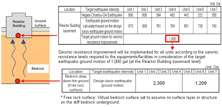
The design basis earthquake ground motion represents the ground motion on the stiff bedrock surface (free rock surface) deep down the ground. Based on this, the ground motion on the Reactor Building basement is calculated. The design basis earthquake ground motion is determined as follows.
1. The active faults considered to have large impact on the power station are selected based on the geological survey results, etc.
2. The earthquake intensity (magnitude) is estimated in consideration of the active fault size.
3. Based on the estimated earthquake intensity, the level of ground motion at the power station is calculated.
Geological Survey of the Surrounding Area of Power Station and Active Faults Evaluation
Geological survey was done in order to obtain information on the underground structure and fault activity in the surrounding area of the power station.
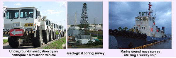
Others: Fault investigation utilizing vertical shafts, GPS survey, aerial photographic survey, etc.
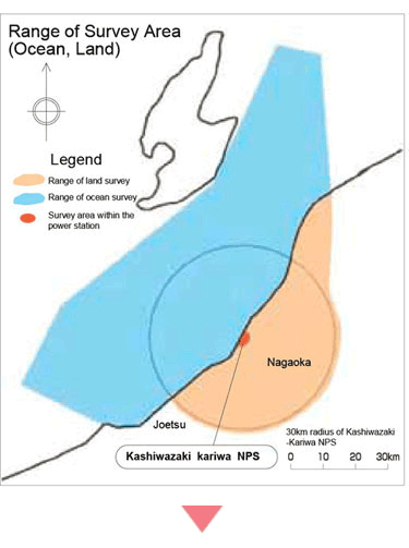
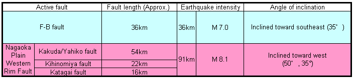
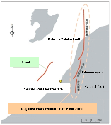
The active faults in the surrounding area of the power station were evaluated in accordance with the new guidelines for earthquake-resistant design set by the government. Of all the active faults evaluated, the "F-B Fault" (ocean area) and the "Nagaoka Plain Western Rim Fault Zone" (land area) were selected as the ones likely to have large impact on the power station. The design basis earthquake ground motion was then determined assuming an earthquake on these faults.
Design Basis Earthquake Ground Motion
Characteristics of the Ground Motion of the Niigata-Chuetsu-Oki Earthquake
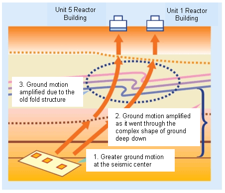
The following 3 factors are considered to have contributed to the increase of earthquake ground motion and the difference in the levels of ground motion on Unit 1-4 (Arahama) side and Unit 5-7 (Ominato) side.
1. The ground motion at the seismic center was greater compared to earthquakes of the similar intensity (M 6.8 level).
2. The ground motion was amplified as it went through the complex shape of the ground deep down.
3. The old "fold structure" of the ground on Unit 1-4 side led to the concentration of ground motion. (Based on the investigation of this earthquake and the ones occurred in the ocean area in the past, it was found that the level of ground motion on Unit 1-4 side was twice as large as that of Unit 5-7 side.)